14
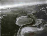
An aerial view of Duck Lake, looking south.1929
Duck Lake, north of Creston, BC
15
Farmers began turning their attention to Duck Lake, Leach Lake and Six Mile Slough. These areas had been included in the 48,000-acre concession granted William-Adolph Baillie-Grohman in 1883, and plans were being made even before the Second World War to drain the lake and adjoining marsh lands.16
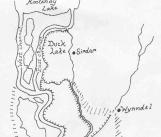
Map of Duck Lake Dyking District.1950
Duck Lake, north of Creston, BC
17
Plans had to be approved by the International Joint Commission, an organisation established in 1909 to oversee activities affecting the Columbia and Kootenay waterways. A proposal put forward by the Creston Dyking District, to reclaim land south of Duck Lake, was approved in October 1950. The primary condition of this approval was that the dyked area be limited to 3,200 acres; the rest of the Duck Lake area was to be left natural for water storage and wildlife management.18
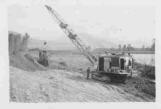
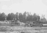
Dragline working at Duck Lake.1950
Duck Lake Dyking District, north of Creston, BC
19
Construction on the Duck Lake dykes began only a few days after permission had been granted. Creston Dyking District, under the direction of R.B. and Alan Staples, took charge of the work. The first part of the process was to divert Duck Creek, which flowed out onto the flats and into the land to be reclaimed.20
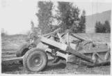
Scraper working on the Duck Lake dykes.1950
Duck Lake Dyking District, north of Creston, BC
21
The original plan was to simply dyke around the perimeter of the land to be reclaimed. Within a short time, though, the Staples realised that the north end would be subject to considerable wind and wave-wash from Duck Lake. A cross dyke was built across the district to protect the south end, in the event that the dykes on the north were ever breached.22
Building dykes at Duck Lake.1950
Duck Lake Dyking District, north of Creston, BC
23
As had been the case in 1935, the Christenson brothers' machinery was used to build the dykes at Duck Lake. As Grant Christenson recalls, "when Duck Lake was dyked that was the same thing: instead of taking money for dyking they took land."As a result, the Christenson brothers owned land in three of the four dyking districts.
24
Map showing the four dyking districts in the Creston Valley.June, 2003
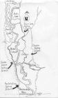
25
Four distinct dyking districts were now well established in the Creston Valley: Reclamation Dyking District, built on the original Alberta and British Columbia Exploration Company's works and encompassing over 7,000 acres across the entire width of the Valley north of the Canada-US border; Creston Dyking District, lying north of the Goat River diversion and east of the Kootenay River; Nick's Island Dyking District, between two channels of the Kootenay River; and, northernmost of the four, Duck Lake Dyking District, immediately south of Duck Lake.26
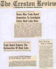
The Creston Review reported on the plans to dyke Duck Lake.1950
Duck Lake, north of Creston, BC