1
The Kootenay Power and Development Company had declared bankruptcy, and many of the farmers on the flats had abandoned their farms and machinery following the flood of 1932.George Salter, a lawyer from Vancouver, was appointed receiver for the bankrupt company. Within a short time, he was talking to the farmers, persuading them to come back and try again. This time, building dykes would be a priority; as Grant Christenson says of his father and uncle, "They realised a major effort would have to be put into dyking. They got pretty serious about it, in 1934."
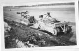
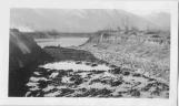
2
Huge scrapers working on the dyking of the flats.1935
Creston Valley, BC
3
Salter's area of concentration was the original Reclamation Farm. Only the northern half of the dyking district would be reclaimed over the winter of 1934-1935; the southern half would be allowed to flood, then dyked in the fall of 1935. The dividing line between the two was Dutch's Ridge, a natural ridge of high ground approximately mid-way along the district.Bill Piper explains that the farmers "shared" the land that year; those who had land in the south, like his father, were given a proportionate part of the crop of a farm on the north end.
Dutch's Ridge was left intact when the south end was dyked. "They were always worried about Boundary Dyke," says Cyril Colonel, "so they left the ridge there as a barrier if the south end ever broke. They hoped it would save the north end."
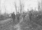
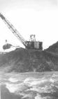
4
Surveyors building dykes on the flats.1935
Creston Valley, BC
5
Surveyors were brought in to help ensure that the dykes were level, and that they were built high enough to withstand recorded water levels.For the first time, previous high water marks were checked: it was discovered that flood levels of twenty-two feet above normal were common, and higher levels had been recorded. The realisation sank in that the dykes would have to be high enough to withstand twenty-five feet of high water. In comparison, the dykes had broken in 1932 under a rise in the river of only 14.9 feet!
6
The Alberta and British Columbia Exploration Company still owned much of the land, as a result of the 1932 bankruptcy. Salter negotiatied with them to reduce the price of the land, from $95.00 an acre to $67.00, at 5% interest. However, instead of paying him one-sixth of their annual crop, as had been the case in 1929-1932, the farmers now paid one-third of the crop. Grant Christenson recalls his father saying that this did not seem a hardship; it got the land paid off faster, and, in Idaho, where they had been farming, "they were paying a third of the crop to rent the land, never mind buying it."In addition, International Harvester offered the machinery back to the farmers for 25% of what was owing on it; the three oil companies in Creston at the time agreed to let the farmers have fuel for the machines and pay for it, at a rate of 150%, when the farms were established. Ultimately, the oil companies refunded the additional 50%, so that money could go towards the purchase of new dyking equipment.
For the Reclamation Farmers Association, things were looking good.
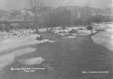
7
Creston Flats, the winter before they would be successfully dyked and used as farmland.February, 1935
Creston Valley, BC
8
At the same time, the Creston Dyking District was being established, primarily under the leadership of Frank and R.B. Staples and Frank Putnam. The Creston Dyking District runs north from the Goat River to Wynndel, along the east side of the Kootenay River.This task could only be accomplished by getting rid of the Goat River, which ran through the centre of the land to be reclaimed.
9
Digging the diversion channel that would allow the Goat River to flow into the Kootenay.1935
Goat River, south of Creston, BC
10
The Goat River flows west into the Creston Valley just south of Creston. When it reaches the edge of the mountains, it swings north in a course roughly parallel to the Kootenay River. Draglines dug a diversion for the Goat River at its turning point; the diversion allowed the Goat River to continue its westward course until it joined the Kootenay River.11
Goat River diversion channel.1935
Goat River, south of Creston, BC
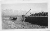
12
This plan brought the Creston Dyking District into direct conflict with George Salter. The diversion meant that all the water from the Goat River was flowing into the Kootenay and pushing against the dykes of Reclamation Farm. Salter was worried that the dykes would not be able to withstand the added pressure.According to Grant Christenson, the issue nearly wound up in court before it was settled.
13
Machinery used to divert the Goat River into the Kootenay River.1935
Goat River, south of Creston, BC
14
Nevertheless, work on the diversion went ahead. Draglines dug the new channel for the Goat River, then opened the bank of the Goat and allowed the water to flow into the Kootenay.With the problem of the Goat River solved, work could begin on the dyking of the Kootenay River.