1
Early Land Use and ExplorationThe Sinixt First Nation, an Interior Salish people, lived on the Columbia River and its tributaries from below the United States border up to present-day Revelstoke. They were a hunter-gatherer people and they used their land-base in a rotational way. They had permanent winter camps established near what is now Revelstoke, but in the traditional land use of the people, they did not come to the same winter camp two years in a row. The Europeans who first came here did not understand this form of land use and felt that the Sinixt had no claim on the land as they were not here all of the time. After European settlement in the northern part of Washington State, the Sinixt began spending more time around the Colville area in order to have access to the trade goods and guaranteed food supply. By the time that the traditional Sinixt land in British Columbia began to be settled, the Sinixt were already considered "American Indians" and their efforts to hunt, fish and gather on their land in British Columbia were met with opposition. Finally, the Sinixt became integrated into the Colville Reservation and in the 1950s all of their Canadian rights were extinguished.
2
Sinixt people on Arrow Lakes.1890
Arrow Lakes, British Columbia, Canada
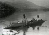
3
Sinixt people in sturgeon nosed canoe on Arrow Lakes, c. 1890s. Photo courtesy of Arrow Lakes Historical Association.4
Explorer and mapmaker David Thompson brought his party of explorers over Athabasca Pass and down the Wood River which empties into the Columbia at the spot where it made a hairpin bend around the north end of the Selkirk Mountains. Little more than 100 yards downstream from Wood River was the Canoe River. Thompson stepped ashore on the flat land between these two rivers on January 26, 1811 and there he established Boat Encampment. After spending the river making boats, his party continued on to the Pacific coast, travelling upstream. On the return trip the party kept to the Columbia River upstream all the way to Boat Encampment. Although Thompson never came west again his route by Athabasca Pass to Boat Encampment and then downstream to the mouth of the Columbia became the main route for travellers, commerce and mail between the prairies and the Pacific Ocean for more than 40 years.5
Boat Encampment.1947
Boat Encampment, Columbia River, British Columbia, Canada
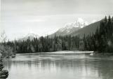
6
Boat Encampment, Columbia River.7
Plaque at Boat Encampment.24 April 2006
Boat Encampment, Columbia River, British Columbia, Canada
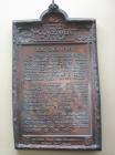
8
Plaque at Boat Encampment erected on completion of Big Bend Highway, 1940.9
For 160 kilometers downstream from Boat Encampment the Columbia River was a series of treacherous rapids and swift water that became the bane of the river travellers. Death Rapids earned its name due to several drowning deaths at that point, and Priest Rapids, just below, were so titled during a trip involving the first missionaries to travel the Columbia River route. After the priests safely arrived down river, the boat returned for the remaining passengers but took on water and overturned in Priest Rapids. Twelve people were killed, including women and children.10
Death Rapids.1947
Death Rapids, Columbia River, British Columbia, Canada
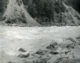
11
Death Rapids, Columbia River, 1947.12
Shortly below Little Dalles (Revelstoke Canyon) where the Revelstoke Dam is now located, the Columbia River takes a great jog and at that spot was a very large and treacherous eddy. This part of the country became known to fur-traders, explorers, missionaries miners and other overlanders as "the eddy." Not far from the eddy was a camp similar to Boat Encampment, where the river travellers could rest. Today with the flow of the river controlled by dams, the eddy has almost disappeared.By 1860 gold was being found on the tributaries of the Columbia River. The Big Bend Gold Rush reached its peak in 1865 - 66 and was over almost as quickly as it started. During the gold rush a small paddle-wheeler, the SS Forty-Nine, made several trips between Marcus, Washington and the mining town of La Porte, 64 kilometers north of present day Revelstoke. Steamboat captain Leonard White had a policy that any travellers coming into the gold fields had to be able to pay full fare and have a winter's grubstake, but he would take anyone out of the Big Bend free of charge if they had exhausted all of their funds and were coming out broke.
13
Section of a tree with a carved blaze.4 June 1866
Columbia River, British Columbia, Canada