1
In 1880, the government of Manitoba created the county of Norfolk, consisting of townships 7 through 12 in ranges 9 to 12 west of the principle meridian. this county was 42 miles north to south and 24 miles wide east to west with the Assiniboine River running almost through the center. This natural division made it very difficult for the residents on the north side of the river to attend the council meeting that were held at Smart's Landing on the south side of the river. Therefore it was decided in 1883 to divide Norfolk County into North Norfolk and Norfolk. The division line was as close to the river as possible. In 1884 Norfolk was renamed South Norfolk and a new seal was created as the original seal was to go to North Norfolk.2
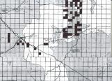
Municipal boundaries on the 1882 map of the Province.1882
Rural Municipality of North Norfolk, Manitoba, Canada
3
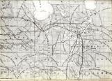
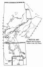
Indian Trails in Rural Municipality of North Norfolk1880
Rural Municipality of North Norfolk, Manitoba, Canada
 Credits:
A Rear view Mirror
4
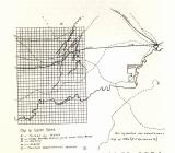
Boundaries of the Postage Stamp Province as defined in 1870Rural Municipality of North Norfolk, Manitoba, Canada
5
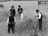
2005 Re-enacting the surveying of the postage stamp province.Rural Municipality of North Norfolk, Manitoba, Canada
6
Re-enacting the surveying of the postage stamp provinceRural Municipality of North Norfolk, Manitoba, Canada

7
Manitoba boundariesProvince of Manitoba
8
Municipality of North Norfolk20th Century, Circa 1930
Rural Municipality of North Norfolk, Manitoba, Canada

9
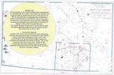
Settlement mapRural Municipality of North Norfolk, Manitoba, Canada