14
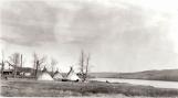
First Nation teepees at the St. Augustine Mission on the Shaftesbury Trail.early 20th century
St. Augustine Mission, Shaftesbury Trail
 Credits:
Provincial Archives of Alberta, A. 10,642
15
A 1915 photograph of Duncan Testawich (Tustawits), to the left, and Dr. Bayfield, to the right. Duncan signed Treaty 8 in 1899 on behalf of the group of First Nations people who became to be known as Duncan's Band.Treaty 8 was of considerable importance to the Peace River area as it established reserves for those First Nations people who signed it. The closest reserve to the community of Peace River Crossing was Duncan's Band which had three lots on the Shaftesbury Trail.
16
Duncan Testawich (Tustawits).1915
Peace River region
 Credits:
PRMA/MC 76.689.39
17
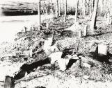
Fort Fork was used by the North West Company until 1805 when it was replaced by Fort Dunvegan. Other than the gardens on the grounds which were used for a number of years the site was abandoned. It became heavily overgrown, as seen here, and began to suffer from river erosion. The fort site was rediscovered and mapped in the 1920s. Unfortunately very little remains today from the site.18
A fireplace at Fort Fork.circa 1920s
Fort Fork, Peace River, Alberta
 Credits:
PRMA/MC AR89.36.39
19
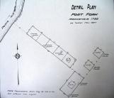
In 1792 Alexander Mackenzie, a major figure in the North West Company, undertook a huge project-trying to find a practical route to cross North America. The start of his explorations which involved crossing the Rocky Mountains to the Pacific Ocean was his wintering post at Fort Fork on the Peace River. In the fall of 1792 he sent men ahead of him to build the post. It consisted of a series of buildings. When the site was drawn in 1927 by the Dominion Land Survey there were 4 buildings found. This included: 2 store houses for good and trade goods; a building that served as Mackenzie's own private living quarters and a longer building to house everyone else.Fort Fork was used by the North West Company as their major post on the central region of the Peace River until 1805. It was important as a trading centre and also as a provisioning post where the local First Nations would trade meat for goods. Another important aspect of the post was its gardens which produced potatoes and turnips.
20
A line drawing of Fort Fork.November 1927
Fort Fork, Peace River, Alberta
 Credits:
PRMA/MC 75.543.207
21
The Fort Fork site has been recognized as a National Historic Site and there is a commemorative cairn located near the fort site.22
The Fort Fork cairn which commemorates the crossing of North America by Alexander Mackenzie in 1793.circa 1920s
Fort Fork, Peace River, Alberta
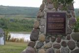 Credits:
Beth Wilkins photograph collection.
23
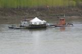
The site of Fort Fork was located on the east side of the Peace River to the south of the present day Town of Peace River. This photograph shows what a visitor to the Mackenzie Cairn on the Shaftesbury Trail sees when looking across the river at the site.24
A ferry crossing the Peace River near the site of Fort Fork .circa 2000-2006
Fort Fork, Peace River, Alberta
 Credits:
Beth Wilkins photo collection.
25
In the 1970s the site of Fort Fork was excavated by provincial archaeologists as it was rapidly disappearing due to soil erosion.26
The Fort Fork Archaeological Site.circa 1970s
Fort Fork, Peace River, Alberta
 Credits:
PRMA/MC 73.569.6