14
St. David's Church was built in 1885, the fourth church built in the community by the Presbyterian families of the Strait of Canso on Cape Breton Island. In 1925, it joined with other Presbyterian, Methodist and Congregationalist congregations to become the United Church of Canada.A ship is seen passing Cape Porcupine on the opposite shore. It was written that a minister once in a prayer said,".... and we thank thee, Lord for the Gut of Canso that separates us from the evil on the other side".
15
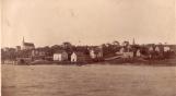
Coal Pier looking north towards village1905
Port Hastings, Inverness County, Nova Scotia, Canada
16
There were several stores in Plaister Cove (renamed Port Hastings in 1869) in the early years that provided goods and services for families in the smaller communities in the district. They also provided for the many ships that stopped for supplies and water. The Victoria Hotel overlooked the Strait of Canso on the southern end of the village. The American Consular and telegraph offices were in the community and Henry A. Archibald had a stage coach line that carried passengers and mail that crossed from Auld's Cove to the rest of Cape Breton Island.17
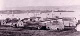
Inverness Railway and Coal Company Pier1912
Port Hastings, Inverness County, Nova Scotia, Canada
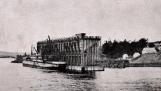
18
The Coal Pier built in Port Hastings in 1901 by MacKenzie and Mann, businessmen from Ontario, provided jobs for many of the men in the district. It was used to ship coal brought in by train from Inverness which was about 50 miles north of Port Hastings. The very deep water immediately off the shore allowed for larger ships to be loaded from the shutes that were lowered on the water side of the Pier.It was in operation until 1927.
19
Boats tied up at the Port Hastings wharf.1910
Port Hastings, Inverness County, Nova Scotia, Canada
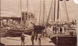
20
The J. B. Martin registered in Charlottetown, Prince Edward Island at the wharf at Port Hastings before 1918 with local resident James A. Skinner on the left. Many of the Skinner men were seamen as were a lot of local men. Some went on the fishing vessels that stopped for supplies back to Glouscester and other New England communities and many remained there.Young women went as well working as maids or taking care of children. Eventually most familes here had relatives in the "Boston States" and elsewhere in the United States.
21
Stone house1830
Creignish, Inverness County, Nova Scotia, Canada

22
Land was settled in small communities like Creignish along both sides of the Strait of Canso by those settlers who arrived sixteen years after the first pioneers had arrived around 1784. This first group settled in the areas of Port Hastings, Port Hawkesbury, Point Tupper and below and around Mulgrave.23
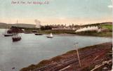
Port Hawkesbury town looking east from the water1910
Port Hawkesbury, Inverness County, Nova Scotia, Canada
24
Merchants such as Nicholas Paint from Guernsey in the British Channel Islands and Peter Paint were two merchant class of Port Hawkesbury in the early years. They were involved and had a significant number of businesses around the fishery- fish plants and shipbuilding.Peter Paint, Jr., son of Nicholas, became the first mayor of Port Hawkesbury in 1889.
25
Point Tupper, Richmond County1878
Port Hawkesbury, Inverness County, Nova Scotia, Canada
26
Ship Harbour, now Port Hawkesbury, was a fish curing station originally and then shipbuilding became an important industry that lead to the growth of a town. Merchants supplied the goods and services for fishing and a shipping industry from Boston to Britain. They also had an American Consular office.The community of Point Tupper is shown on the opposite side of Port Hawkesbury harbour. Unlike the drift ice that moved back and forth according to the tides out in the Strait of Canso, the ice would freeze solid in this sheltered harbour between these two communities allowing for horse races in the winter as well as ice skating and a more direct crossing for those travelling back and forth.
27
Ships looking north from head of the harbour1905
Port Hawkesbury Waterfront