14
The trail from Cobiquid (Truro) to Tatamagouche, rough in places, followed the Chigonois River18th Century, Circa 1710
Earl Town, Colchester County, Nova Scotia
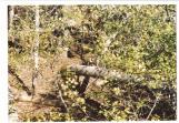 Credits:
Charlotte Moody
15
British soldier re-enactors from the Acadian Deportation period18th Century, Circa 1755
Remsheg, one of 19 ways to spell the Mi'kmaq name for the village in Nova Scotia now Wallace
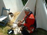 Credits:
David Dewar
16
Lt. Governor of Nova Scotia, Charles Lawrence; The Deploration took place under his command8th Century, Circa 1753
Nova Scotia
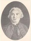 Credits:
Nova Scotia Archives
17
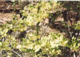
Re-enactment soldiers of the Deportation period18th Century, Circa 1755
Remsheg, one of 19 ways to spell the Mi'kmaq name for the village in Nova Scotia now Wallace
 Credits:
David Dewar
18
Captain Willard stopped a few miles from Cobiquid to read his sealed orders14 August 1755
Earltown, Colchester County, Nova Scotia
 Credits:
Charlotte Moody
19
Re-enactment of twenty British and New England soldiers on a march through the woods to Remsheg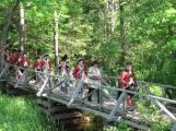
20
Acadian expulsion orders being carried out in Remsheg15 August 1755
North Wallace Road, Wallace Bay Cumberland County, Nova Scotia
 Credits:
Barbara Clark
21
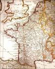
Map of 17th Century France showing the area in Normandy from which many of the French came to Acadia18th Century
France
 Credits:
Wallace and Area Museum
22
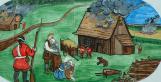
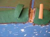
Dykes and Aboiteaus18th Century, Circa 1720
Nova Scotia
Dykes and aboiteaus were used by the Acadian settlers to protect and improve the fertile marshland.
First, the Acadians would build a dyke to surround a desired marsh area, to protect it from tidal flooding. These dykes were all constructed by hand using simple hand tools, sleds, and sometimes oxen. Some dykes could be several kilometres in length. Normally they would be built about 3 metres above the high water mark. The average daily tide rise in this area is 1.5 to 2.5 metres, but can be much higher in the spring and fall. Places had to be found to excavate fill to build the dyke. In today's construction these areas are called "borrow pits". Aerial photos show many pitts along dyke construction, telling us the material was always near to the construction site.
Next, the farmers would install an aboiteau in the low areas along the dyke. An aboiteau is a simple wooden valve using a wooden flap to control water flow. It was installed to allow rain water or snow melt water to drain from the land which helped leach out the salt from marsh soil, making it very productive farm soil. The leaching process took three to four years.
When a breach of a dyke happens, through storms or floods, it was devastating for farmers to lose large sections of their crop land.
Credits:David Dewar
23
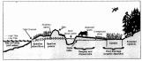
Diagram of a working dyke18th Century,
North Wallace Road, Wallace Bay Cumberland County, Nova Scotia
 Credits:
Nova Scotia, Ducks Unlimited Amherst
24
Rich marshland at Remsheg Bay, first seen by Acadian farmers in about 171021st Century, Circa August 2010
North Wallace Road, Wallace Bay Cumberland County, Nova Scotia
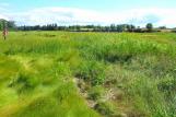 Credits:
David Dewar
25
Model of working aboiteau; in the foreground are drainage ditches sloping to the aboiteau at the top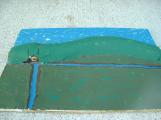
26
Model of a working aboiteau18th Century design. Circa 1720
Tuttle Creek, Wallace Bridge, Cumberland County, Nova Scotia.
 Credits:
Jim Reeves, model maker
Zella Perry, Photographer
27
Map of North Cumberland County area with evidence of Acadian habitationModern map of 18th Century Acadian life
Northumberland Strait, Cumberland County, Nova Scotia.
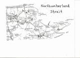 Credits:
David Dewar