1
The NameFor many years before its name became synonymous with the Canadian Nuclear Industry Chalk River had been a vibrant center of activity in the Upper Ottawa Valley. The origin of the village however and the derivations of it's name remain unknown to many of its residents.
Contrary to popular belief, Chalk River does not owe it's existence to the building of the Canadian Pacific Railway (C.P.R). The presence of the C.P.R. however did contribute to the rate of development of the area. The area was inhabited originally by farmers and lumbermen who relied on the Ottawa River as a means of transportation into the area. These early pioneers settled mainly within a three mile radius of the village as it exists today, but some as far away as the Deep River / Wylie district.
The village was known originally under two different names, as attested by deeds dating back as far as 1883 and registered in the Renfrew County Land Registry Office in Pembroke.
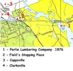
The area lying Northeast of the railway yard was known as Coppsville. It was named after Mrs. Ellen Copps who owned a large portion of land in this area. The area southwest of the railway was known as Clarksville, after the Clark family who owned a substantial section of land in this district. The Clark name is still retained today in reference to Clark's Landing, a popular beach area off Corry Lake for the town's people and its access road "Clarks Landing Lane".
By 1876 the Canadian Central Railway (C.C.R.) was completed as far west as Pembroke and was extended gradually over the next few years to Petawawa and then to Chalk River. In 1880 the C.C.R became part of the Canadian Pacific Railway.
The Chalk River from which the village takes its name , probably owes its name to the Perlie Lumbering Company which was established around 1876 on the banks of the lake where Chalk Bay meets Sturgeon Lake. The water flows from Corry Lake into the Chalk River, into Sturgeon Lake and eventually into the Ottawa River providing a natural water route for transportation of material into and out of this region.
This was an ideal location for the lumber company as the river served a large timbering area. It provided easy transportation for cut timbers from as far south as Tucker Creek and as far west as the head of Corry Lake, for eventual hewing at Perlie Mill, or hewing site. The gradual downward slope of the area's terrain also permitted the use of horse and sleigh in the timber transportation, both to the banks of the Chalk River and directly overland to the hewing or mill site.
2
Locations of early settlements in Chalk River area1900
Chalk River, Ontario, Canada
3
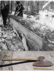
Since the circular saw had not yet been introduced to this area , the timbers were squared by broad axes at the mill site, before being floated into the Ottawa River for destinations further downstream.
As shown in the accompanying photographs, the broad axe, unlike our axes of today has a very broad (8 to 10 inch) cutting edge and is sharpened only from one side. The sharpened edge allows for easy cutting into the log while the flat side resulted in a flat or square cut on the log.
Much like today's hockey sticks , the broad axe handle was set into the axe head with either a slight angular inclination to the left or the right to facilitate left or right handed choppers. Compared to today's axes, the heavier broad axes provided more driving force into the chopping action.
The men who were responsible for the hewing (squaring) of the logs could not always rely on their keen eye for maintaining a straight cut, and relied heavily on a straight chalk like marking on the bark of the log for guidance. The chalk like substance used to mark the logs was obtained from the char of burnt alder or poplar sticks. The hewers rubbed this substance , sometimes called "Black Stick" or "Chalk" against a string line and used the line much like today's carpenters use a chalk line. The line was stretched horizontally along the log, tightened , and after snapping the line against the bark of the log, a black chalk marking was left.
The "Chalk Bay" of today and the site of this hewing operation was apparently named after the chalk like substance used in marking the logs. Because of their relationship with each other, the river leading into Chalk Bay from Corry Lake soon became known as the Chalk River.
Later on, a small settlement to the north of the Chalk River , and owned by Mr. William Fields and family also became known as Chalk River. This settlement was located near the road running from Pembroke to Mattawa and served as a stopover place for portagers, as well as a place for local inhabitants to pick up supplies and mail services.
When the C.P.R came upon this settlement as they were pushing the railroad further west, they stopped over temporarily at this settlement until their course of direction was finally settled.
The Canadian Pacific Railway was finally destined to run up through the area of Coppsville and Clarksville. A permanent depot, including a service shop and divisional point between Ottawa and North Bay was established. This divisional point was set up 1 and 1/4 miles (2 Km) West of the original "Chalk River" and was also named Chalk River Divisional Point around the year 1880.
Despite the fact that the C.P.R. adopted Chalk River as the name for their Divisional Point, a parcel of land in the Coppsville area northeast of the railway yards was still known to be located in the Coppsville area, as attested by a land deed registered in 1883.
4
Timber squaring1900
Ottawa Valley, Ontario, Canada
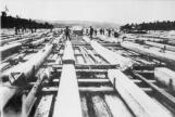
5
Squared timber rafts on the Ottawa River1900
Ottawa Valley, Ontario, Canada