1
The Search for Franklin
Franklin Expedition
2
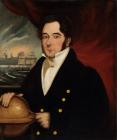
Captain John Franklin, leader of the ill-fated expedition to discover the Northwest PassageCirca 1845
 Credits:
Artist unknown
The Mariner's Museum, Newport News, Virginia, USA
http://www.mariner.org/exploration/mm_images/QO221_SirJohnFranklin_large.jpg
3
Many expeditions were sent to the Arctic due to Britain's continued interest in discovering the Northwest Passage, which would allow ships from Europe and eastern North America to reach Asia through the Arctic, instead of sailing around Africa. One such expedition was headed by Sir John Franklin in 1845, with a crew of 139 men, 2 ships - the Erebus and the Terror - and enough supplies for three years. When there was no news after two years, the British Admirality sent out four search parties, however, they found only ice and snow. The British public, and especially Franklin's wife, Lady Jane Franklin, demanded results. Between 1847 and 1859, thirty-two search expeditions were undertaken.Some of the crew are said to have survived until 1850 after becoming icebound. The downfall of the Franklin Expedition has been linked to lead poisoning, from the food tins. There is also the suspicion of cannibalism among the crew members in the final days of their lives.
4
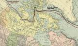
Route taken by Franklin and the later successful route through the Northwest passage by Amundsen1845-1848, 1903-1906
 Credits:
Created in Photoshop using
http://www.robinsonlibrary.com/geography/geography/arctic/graphics/nwpassage2.gif> and
5
The Search for Franklin
Dr John Rae
6
While surveying Boothia Peninsula in 1854, Dr. John Rae, a Hudson's Bay Company surgeon and mapmaker, met with an Inuit man wearing a gold-braid naval cap band. When the Inuit was questioned about the band, Rae learned that a party of white men had starved to death near a large river not far away. He returned and announced that he had heard stories from Inuit near Pelly Bay, and had reason to believe that members of the Franklin Expedition must have perished near the estuary of Back River.7
Dr. John Rae (1813-1893), surgeon and mapmaker for the HBCCirca 1860
 Credits:
http://www.clan-macrae.org.uk/scotland/clientimages/johnrae.jpg
8
The Search for Franklin
Anderson & Stewart Expedition
9
As the Admirality had already used many resources, and with the outbreak of, and need for ships in, the Crimean War, the government requested that the Hudson's Bay Company send a search party up Back River to verify Rae's account.In 1854, James Anderson, who was stationed at Fort Simpson on the Mackenzie River, and James Green Stewart were appointed by Sir George Simpson, the Company's Governor in North America, to head a search for the Franklin expedition.
10
Rae recommended that shortened north canoes and an inflatable raft be used rather than the heavy boat used by George Back in 1834, as they would make navigation in the Arctic easier. However, 2nd in command, James Green Stewart, allowed inferior bark to be used in construction of the shortened north canoes.Anderson commented on the canoes: "they were of an excellent model, the woodwork very strong, but the bark, though the best that could be procured at so short a notice, was very inferior. They were, of course, very heavy; their ladings amounted to 24 pieces of 90 pounds each, and consisted chiefly of provisions, with a good supply of ironworks, &c."
The party started out from Great Slave Lake with fifteen boatmen, three canoes, and an inflatable raft. Many of the men selected to accompany Anderson and Stewart had previously served under Rae. However, they were not able to find an Inuktitut interpreter, and were also delayed by a late spring thaw.
They left Fort Resolution on Great Slave Lake on June 23, 1855, and saved time by taking an arduous mountain portage northward. They navigated over 80 rapids and falls, and reached the sea at the mouth of Back River at the end of July. However, Chantrey Inlet was clogged with ice floes, and the canoes would not work as icebreakers.
11
Shortened north canoes were used on the Anderson-Stewart Expedition Credits:
North West Company Fur Post, Pine City, Minnesota
http://www.mnhs.org/places/sites/nwcfp/images/exhibits.jpg
12
On July 31, the crew met with Inuit who were in possession of various articles from European boats. The party had to communicate with the Inuit through makeshift sign language. Anderson wrote that "the communications, eked out by signs, were necessarily very imperfect, but the conclusion arrived at, and it was doubtless a just conclusion, was that the [Franklin] party after reaching the mouth of the Great Fish River [a.k.a. Back River] in an exhausted condition, had perished there from hunger."13
Anderson and Stewart met Inuit on the journey and asked questions about the lost Franklin Expedition1854
 Credits:
p. 148, Feb. 18, 1854, The Illustrated London News
http://www.sil.si.edu/PAID/fullsize/picturingwords/SIL32-010-03.jpg
14
Anderson's crew explored Montreal Island, searched the shoreline, and found tools and wood and metal fragments, one bearing the name Terror, along the shore and in Inuit caches. One fragment of a snowshoe bore the name "Mr Stanley" of the Erebus.Anderson wanted to search Cape Richardson, but was prevented by jagged ice streams. If he had, he would have found - 8 km west, in a cul-de-sac later known as Starvation Cove - the last encampment of the Franklin Expedition.
At the beginning of August, ice prevented the canoes from travelling farther. Anderson's party searched the mainland, then turned back, as the frail canoes could not cope with sea ice off the Arctic coast. On their return journey, they had to navigate the 80-odd rapids and falls, over 1500km, safely before winter. They arrived at Fort Resolution mid-September.