1
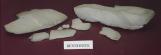
Mining in the Pembina Hills led to the discovery of the largest collection of marine vertebrates in Canada.2
Glaciation1982
Canadian Fossil Discovery Centre, Morden, Manitoba, Canada
3
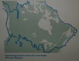
The topography or landscape we see today was not always present. The northern portion of North America was covered by a glacier approximately 18,000 years ago. Outlined in blue is the extent of this massive glacier.A glacier is a large mass of solid ice, growing and moving over the landscape. As the glacier grows and moves it scours and removes layers of rocks and sediments from the land. As a result the Manitoba Escarpment was left behind.
4
Lake Agassiz1982
Canadian Fossil Discovery Centre, Morden, Manitoba, Canada
5
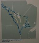
Approximately 12,000 years ago the glacier began to melt and retreat. Melting of the glacier resulted in large amounts of water covering the landscape. Water accumulated in the lowest areas, or depressions that remained from the weight and scouring of the glacier creating glacial lakes.The blue outlined area represents the extent of one of those glacial lakes, Lake Agassiz. The western shoreline is the Manitoba Escarpment and the bottom of Lake Agassiz is now referred to as the Red River Valley.
6
Red River ValleyJuly, 2002
Morden-Miami area, Manitoba, Canada
7
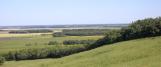
The Manitoba Escarpment is approximately 1,500 to 1,600 feet above sea level. The incline from the Red River Valley is approximately 500 feet.This view was taken from the top of the Manitoba Escarpment, looking southwest over the Red River Valley.
The Manitoba Escarpment runs in a North West direction from North Dakota into Saskatchewan. The escarpment and area is also referred to as the Pembina Hills.
8
Rock exposure1980
Morden-Miami area, Manitoba, Canada
9
The rock layers composing the Manitoba Escarpment (Pembina Hills) are mainly from the Pierre Shale Formation. A formation is a number of different types of rocks forming a larger group. The specific type of rock the fossils are found in is referred to as the Pembina Member. This unit is approximately 80 feet thick, with many surface exposures to find fossils.10
Replica of rock layers1980
Canadian Fossil Discovery Centre, Morden, Manitoba, Canada
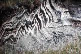
11
There are 13 specific layers of bentonite within the Pembina Member of the Pierre Shale Formation. The brown layers are the mineral bentonite alternating with the black layers of the rock shale.Shale is a type of sedimentary rock where the fossils at the Canadian Fossil Discovery Centre (formerly the Morden and District Museum) are found. Bentonite is the mineral that was being mined at the time.
12
Shale2003
Canadian Fossil Discovery Centre, Morden, Manitoba, Canada
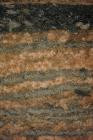
13
In this image is the rock shale. When exposed, the Pembina shale is ash grey in colour. The shale can hold a lot of water, and when wet is dark black in colour.14
Bentonite2003
Canadian Fossil Discovery Centre, Morden, Manitoba, Canada