1
The Peace River itself stretches over 1,300 kms from its source in northern British Columbia to where it flows into the Slave River near Lake Athabasca in northern Alberta. For the steamboat operators of the early 20th century only about 900 kms was navigable on an average year. This was the portion of the upper Peace River from Hudson's Hope in northern British Columbia to the Vermilion Chutes (a series of rapids) near the modern day Town of Fort Vermilion in northern Alberta. The major obstacles to use of the river were canyons, rapids, islands, sand bars, and man made structures.2
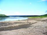
The Battle (Notikewan) River.Summer 2008
Battle (Notikewan) River
 Credits:
Peter Wood
3
The furthest eastward point on the upper Peace River that was navigable was a series of rapids which had retained its name from the fur trade era, the Vermilion Chutes. Due to their size steamboats could usually only be brought over the Chutes when water levels were high and this was only done when boats were being moved to other river systems. In the steamboat era of the upper Peace River the Chutes became the eastern end/start point of navigation. Passengers and freight could be taken through the Chutes in small boats and transferred to other vessels which could travel to the Mackenzie and Athbasca Rivers. Steamboats anchored at the Chutes could also pick up freight and passengers that had come via the latter.4
A scow trapped in the Vermilion Chutes.Circa 1917-1921
Vermilion Chutes, Alberta, Canada
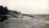 Credits:
Peace River Museum, Archives & Mackenzie Centre, AR89.30.009
5
A scow on the rapids on the Vermilion Chutes.Circa 1917-1921
Vermilion Chutes, Alberta, Canada
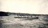 Credits:
Peace River Museum, Archives & Mackenzie Centre, AR89.30.010
6
A scow being tracked through the Vermilion Chutes.Circa 1917-1921
Vermilion Chutes, Alberta, Canada
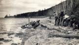 Credits:
Peace River Museum, Archives & Mackenzie Centre, AR89.30.020
7
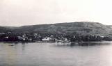
The S.S. Peace River anchored at the Hudson's Bay Company post at Fort Vermilion.Circa 1905-1915
Fort Vermilion, Alberta, Canada
 Credits:
Alberta Historic Sites, Reference Collection
8
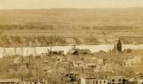
450 kms. upstream from Fort Vermilion was the major centre on the upper Peace River, Peace River Crossing. This community was to become the major commerical centre for the region as it was connected to the Grouard Trail, an overland route to Lesser Slave Lake which provided access to Edmonton. Peace River Crossing was to be home for most of the steamboats used on the upper peace River.9
The S.S. D.A. Thomas and S.S. Athabasca River at Peace River Crossing.Circa 1918-1930
Peace River Crossing, Alberta, Canada
 Credits:
Peace River Museum, Archives & Mackenzie Centre, 2008.056.003
10
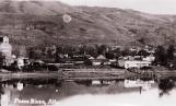
Steamboats docked at Peace River Crossing.Circa 1918-1930
Peace River Crossing, Alberta, Canada
 Credits:
Peace River Museum, Archives & Mackenzie Centre, 2008.056.003
11
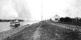
Peace River Crossing.Circa 1919-1930
Peace River Crossing, Alberta, Canada
 Credits:
Peace River Museum, Archives & Mackenzie Centre, 2008.056.003
12
A barge at the Hudson's Bay Company docks, Peace River Crossing.19 May 1921
Peace River Crossing, Alberta, Canada
 Credits:
Peace River Museum, Archives & Mackenzie Centre, AR89.30.007
13
The dock area on the east banks of the Peace River at Peace River Crossing.Circa 1916-1930
Peace River Crossing, Alberta, Canada
 Credits:
Peace River Museum, Archives & Mackenzie Centre, 2004.007.002
14
The Hudson's Bay Company dock area at Peace River Crossing.Circa 1916-1930
Peace River Crossing, Alberta, Canada
 Credits:
Peace River Museum, Archives & Mackenzie Centre, 80.1150.001