1
The Loyalist Townsite of Fanningboro was suggested and surveyed by the British Government. Each person who was eligible for the land grant was given a draw from hat full of numbers. Each number represented a surveyed propery in the large 20,000 acre Remsheg land grant. Loyalists were also given draws from a hat full of numbers for 3 acre properties in the Townsite of Fanningboro. There were 238 townsite lots of which James Dotten drew #233. James Dotten and his also drew 357 for their farm lot. The Dotten family have lived on this property since arriving here in 1783.Unfortunately the Isolated Townsite was never very successful. Only a few families built on their townsite lot. Infact man people within a year or so gave up or traded their grants inorder to move to more populated areas like Saint John and Halifax
2
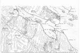
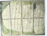
Remsheg land Grants of 1783, Showing around the Village of Wallace, Fanningboro and Oak Island18th Century, Circa 1783
Remsheg land grant includes 20,000 acres of land fronting on the Northumberland Strait, in Northern Nova Scotia
 Credits:
Wallace and Area Museum
3
A map showing the land in the Remsheg area granted by the British Government to the Refugees.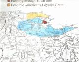
4
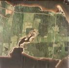
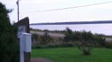
Present day view of the Fanningboro site, Fanningboro was the proposed Townsite for Loyalist Grant15 June 2012
Fanningboro, Cumberland County
 Credits:
David Dewar
5
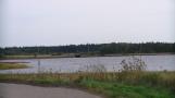
Browns Bay, part of the Fanningboro survey. Water access to John Browns property.25 August 2012
Fanningboro, Cumberland County
 Credits:
Jim Reeves
6
Unitd Empire Loyalist Memorial at the Fanningboro Townsite, in North Wallace15 August 2012
Fanningboro, Cumberland County
 Credits:
Jim Reeves
7
Wallace Harbour 2012 picture taken from Fanningboro.15 August 2012
Wallace, formerly called Remsheg
 Credits:
Jim Reeves
8
Survey of Fanningboro,three acre lots, Drawn 1784 by Charles Baker18th Century, Circa 1784
Fanningboro, Cumberland County
 Credits:
Marion Dotten and Alex Dotten
Zella Perry, Photographer
9
Wallace Harbour from the Loyalist Monument on the Fanningboro Loyalist Remsheg site.15 August 2012
Fanningboro, Cumberland County
 Credits:
Jim Reeves
10
Heavy growth on site of John Brown,s tradigic first home. John and daughter struck by lightening.25 August 2012
Fanningboro, Cumberland County
 Credits:
Jim Reeves
11
The original northern roadway of Fanningboro running parallel with the Bay at Fox Harbour15 August 2012
Fanningboro, Cumberland County
 Credits:
Jim Reeves
12
East end road of Fanningboro, the townsite surveyed for the Remsheg Grant15 August 2012
Fanningboro, Cumberland County
 Credits:
Jim Reeves
13
Green Street, one of the surveyed roads on the original Remsheg Grant15 August 2012
Fanningboro, Cumberland County
 Credits:
Jim Reeves
14
This small Island in Remsheg Harbour is called Oyster Island. Today its a great spot for nesting Great Blue Herons. Around the beginning of the 20th Century it became the north end support, for the relatively long Livingstone Bridge. It is quite small, however it shows up on early charts of the Harbour, done prior to 1840. There are many oysters found near the Island but perhaps the inspiration for the name came from the Loyalists.One of the last Islands the Loyalist would see when leaving New York Harbour is one called Oyster Island.