1
Innisfail and its Early HistoryInnisfail, Alberta lies just west of Highway 2 on the Edmonton-Calgary corridor in the heart of central Alberta. It is 32 kilometers south of Red Deer and 117 km north of Calgary. In 2001, the town had a population of 6958 and acted as a service centre for 15,250 in the surrounding area. While Innisfail started off as an agriculturally community but today most people do not work in jobs directly related to this activity.
Innisfail's first claim to fame is it relationship to Anthony Henday. Prior to October 1754, no European had ever traveled in the area of present-day Innisfail. Native peoples camped near the site, presumably for generations. In 1754, Anthony Henday, who had come to the region with the goal of starting trade relations with the Blackfoot, was the first white man to record seeing the Rocky Mountains. It is assumed he saw the Rockies from Antler Hill, the highest point between Edmonton and Calgary and just north of Innisfail.
2
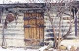
A 'stopping house' in Poplar Grove that provided accomodation for visitors.16 February 2004
Innisfail, Alberta
3
Stopping houses such as this were what first established Innisfail (then referred to as Poplar Grove) as a stopping ground for travelers and possible site for permanent settlement. Without these stopping houses, the community of Innisfail would not have developed at such a rapid pace, or maybe even at all.4
Another man who made his way through the Innisfail area relatively early was Reverend John McDougall. In the 1870s, McDougall was creating a trail from Fort Edmonton to the church he had set up at Morley; this trail ran through the current Innisfail areaThe 1880s saw the arrival of the first settlers in the Innisfail area. People like Sandy Fraser, Napoleon Remillard, the Browns (two brothers and a sister) and William Kemp were among the first to settle down. The Edmonton-Calgary Trail, which ran right through the area, brought many people through the spot, then known as Poplar Grove. It was a resting place among freight and stagecoach crews. In fact "Stopping Houses", places where visitors could rest during their travels along the Calgary-Edmonton route, are what brought about permanent settlement in the area. Places like "The Spruces", one of the stopping houses in the area, provided a hospitable shelter for visitors.
The population really surged with arrival of the Canadian Pacific Railway. Constructed in 1890-91, it brought droves of settlers with it. It was also around this time that the town's name switched from Poplar Grove to Innisfail. By the turn of the century, Innisfail had a population of 317.
5
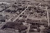
Innisfail circa 1939.1939
Innisfail, Alberta
6
This picture depicts what the Innisfail community looked like at the time of the Second World War. Many of the same landmarks still exist in the town today, such as the water tower.7
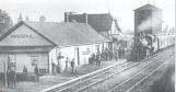
The Innisfail railway station in the 1890s.1890
Innisfail, Alberta
8
This is Innisfail's railway station, which was a big factor in the rush of settlers in the early 1890's. The railway brought trade and visitors to Innisfail, and helped enormously in the development of the town's economy.9
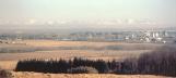
A modern shot of the Innisfail area.16 February 2004
Innisfail, Alberta
10
This is the view of the Innisfail area from the top of Antler Hill, just north of the town. This is likely where Anthony Henday caught his first glimpse of the Rocky Mountains.11
Innisfail was predominantly settled by people of British origin. During the first half of the 20th century the people of Innisfail and the surrounding area retained a strong identity with Britain. Consequently when the call went out for people to join in the war effort during World War I, a proportionately large fraction of the male population answered the call. As a result a large number (at least 55) of young men from Innisfail died relative to the population of the area at the time.For similar reasons a relatively high proportion of young men from the region enlisted to fight in World War II. However the death toll was not nearly as severe in WWII as in WW I. Thirty one service personnel from Innisfail died in WW II but that was a much smaller proportion of the total population than in WW II.
Innisfail society was affected by WW II in other ways as well. There were three pilot training facilities in the Innisfail area: Penhold, Big Bend (a rural district about 15 km NW of Innisfail) and the Bowden Air Base about ten km south of Innisfail. Immediately after WWII, the Bowden base was turned into a correctional facility. Today it is a Federal Penitentiary that employees a significant number of people from the area. The Big Bend air field has become the Innisfail Airport, used primarily for recreational flying. The Penhold base, located about half way between Innisfail and Red Deer retained its training function for more than 25 years after the end of WW II. It has become the Red Deer Municipal Airport.
After WW II many soldiers returned with new brides that they had met overseas, mostly in Britain. These 'war brides' settled into the community and had a significant impact on the local social structure.