Revelstoke Museum and Archives
Revelstoke, British Columbia
1
From Farwell to Revelstoke: Town DevelopmentB.C. Surveyor Albert Stanhope Farwell made out a provincial application for a land grant at what is now Revelstoke on October 20, 1883. The CPR route had not yet been registered, although Sir Sandford Fleming had advised the B.C. Government on September 28, 1883 that he had examined and approved the route-line and the company was ready to begin construction. The CPR registered their route in November of 1883, one month after Farwell applied for his grant and the provincial government reserved land 20 miles wide on each side of the mainline in favour of the CPR, excluding lands already granted to other parties. It was widely believed that Farwell knew that these lands would be in the railway belt and that the line would cut through his lands.
2
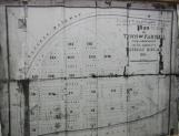
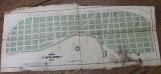
Plan of the Town of Farwell (Revelstoke)1885
Revelstoke, British Columbia, Canada
3
Plan of the Town of Farwell (later Revelstoke), 1885.4
Farwell received title to his Crown Grant of 1175 acres in January of 1885 and the townsite map was completed.5
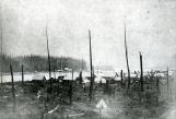
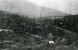
Town of Farwell (Revelstoke) after a fire.1885
Revelstoke, British Columbia, Canada
6
Town of Farwell after a fire, 1885.7
The original Farwell townsite consisted mainly of Front Street, along the banks of the Columbia River. The first buildings were crudely constructed and some of the early hotels were nothing more than large canvas tents. Much of the town was destroyed in a fire on May 1, 1885, but within weeks, the town was rebuilt. It was very much a "wild west" construction town, complete with hotels, saloons, general stores and brothels.8
Reminiscences of Colonel Edward Mallandaine. 'The Town of Farwell' Read by Jules Thomas.29 June 1940
Revelstoke, British Columbia, Canada

9
Reminiscences of Colonel Edward Mallandaine, June 29 1940 'The Town of Farwell'Read by Jules Thomas.
10
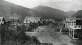
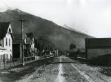
Looking north west on Front Street.1890
Revelstoke, British Columbia, Canada
11
Looking North West on Front Street, 1890.12
Cyclists on Front Street.1895
Revelstoke, British Columbia, Canada
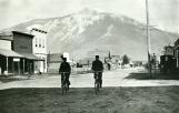
13
Cyclists on Front Street, 1895.14
Front Street1889
Revelstoke, British Columbia, Canada
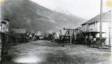
15
Lower Town 1889.16
A.S. Farwell attempted to sell land to the CPR, but his offers were rebuffed. The CPR instead chose land outside of Farwell's grant and established their station and yards there. At the same time, they started legal proceedings against Farwell. The case spent years in the courts before it was finally settled in 1895. This delay made it difficult for the town to advance as people could not get clear title to their lands.17
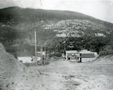
Looking towards C.P.R. yards.1890
Revelstoke, British Columbia, Canada
18
Upper Town looking towards CPR yards, 1890.19
Article in Kootenay Star: Feb. 16, 1892: "Revelstoke: How the Station was Built a Mile and a Half away." "Farwell, who was then in possession of the townsite, made arrangements with Mr. Abbott, superintendent of the Pacific division, CPR, for the transfer of 80 acres of land to the company for the purpose of a station. Had this been carried out, Revelstoke would have been one compact town, instead of being cut in two by a mile and a half of lonely, burnt-up timber�Mr. Van Horne would have nothing to do with Farwell or his offer, and upset the arrangement to build the station on land belonging to the CPR, and thus Revelstoke remains in two parts - the old and the new."20
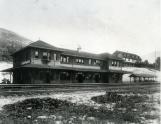
Revelstoke C.P.R station, hotel and yards.1915
Revelstoke, British Columbia, Canada
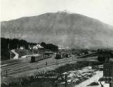
21
Revelstoke C.P.R station, hotel and yards, 1915.22
In 1886, the CPR petitioned the Dominion Post Office department to change the name of the townsite from Farwell to Revelstoke. This name honoured Edward Baring, First Lord Revelstoke, whose British banking firm had saved the CPR from bankruptcy.23
Plan of Revelstoke showing Government Street.1897
Revelstoke, British Columbia, Canada
24
Plan of Upper Town showing Government Street, 1897.25
Government Street was constructed as a shorter route for businesses to transport their goods from the station to their stores on Front Street. The extra expense in shipping costs caused many businesses to relocate to the station townsite that was being constructed on Mackenzie Avenue and First Street.26
Mackenzie Avenue1898
Revelstoke, British Columbia, Canada
27
Mackenzie Avenue 1898.28
First Street1900
Revelstoke, British Columbia, Canada
29
First Street, Revelstoke, c 190030
By the time that World War I began in 1914, Revelstoke was a prosperous community, one of the largest in the interior of the province. The city boasted three banks, a YMCA facility, an Opera House, a high school and two elementary schools. Revelstoke was a transportation, mining and lumbering centre as well as a tourist destination that advertised itself as the "Capital of Canada's Alps."31
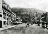
Mackenzie Avenue1912
Revelstoke, British Columbia, Canada
32
Mackenzie Avenue, 1912.33
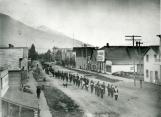
Race between fire brigades on Front Street.1897
Revelstoke, British Columbia, Canada
34
Race between fire brigades in Lower Town.35
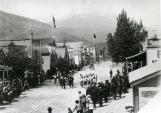
Funeral procession on Front Street.1906
Revelstoke, British Columbia, Canada
36
Lodge procession on Front Street, 1900.37
By the mid 1910s, Front Street was fading away as a business centre, although it still housed three large hotels. It was considered the less desirable section of town, where several brothels were still in operation. By the 1950s, there were less than a dozen of the original buildings still standing on Front Street. The street has since been rebuilt as a residential area.38
Revelstoke CPR Station and Hotel.1908
Revelstoke, British Columbia, Canada