1
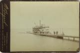
Steamer Enterprise loading and unloading at Jackson's Point.1900
Lake Simcoe, Jackson's Point, Ontario, Canada
2
"In the settlement of the province, the pioneer at first followed the course of the shores of the lakes, bays, rivers and the smallest streams. And wherever was found an Indian path, it was pursued."-Historical Atlas of York County. Toronto: Miles and Company, 1878
3
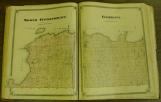
North Gwillimbury and Georgina Townships as shown in this atlas.2006
4
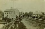
Georgina Township, named in honour of George III during the governorshop of Simcoe, was surveyed in 1917 by Duncan McDonald under instructions from Surveyor-General Thos. Ridout. From 1826 to 1970 the township was separated for administrative purposes into two townships: North Gwillimbury to the west and Georgina to the east. The township, comprising 34,996 acres, is characterized by varied soil conditions ranging from good agricultural land to swampy and sandy soil. It was her pine-forested shoreline, however, which produced the most interesting centres of development, and although small pockets developed in Udora, Egypt, Baldwin, Vachell, and Virginia, the three principal settlements in the 19th century were Sutton, Pefferlaw, and the Lake Shore Road.5
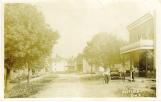
Pefferlaw looking east.1914
Main Street, Pefferlaw, Ontario, Canada
6
High Street, Sutton.1900
High Street, Sutton, Ontario, Canada
7
Baldwin.1905
Baldwin, Ontario, Canada
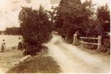
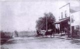
8
On Lake Shore Drive, looking east towards Jackson's Point.1915
Lake Shore Drive, Jackson's Point, Ontario, Canada
9
North Gwillimbury grew up around four centres: Roche's Point, Keswick, Jersey, Belhaven. Historically, Lake Simcoe and the Holland River formed the principle communication route from the north to the south of Upper Canada, and North Gwillimbury held a beneficial position along this route. "Upper Canoe Landing," in early days, was a site much used by Natives engaged in bartering with the fur traders. A mile and a half further down from the Upper was the "Lower Landing." Here, with the Holland River is about 25 feet wide, was "Pine Fort" also known as "Gwillimbury Fort."Gov. Simcoe, realising the importance of good communications for the new Province, caused a survey of a route from Toronto to Lake Simcoe to be made in 1795. It was called Yonge Street after Sir George Yonge, Secretary of War in the Home Government of 1791. By 1829 a stage coach was able to make daily trips along this route from Toronto to Holland Landing. It provided seats for six passengers and was drawn by four horses. This meant untold benefits for the growing township. In 1821 the total number of inhabitants in North Gwillimbury and Georgina was 272. The next year it had risen to 314 and in 1829, North Gwillimbury alone had 339 inhabitants.
The town of Belhaven, formerly known as "Plug Mount," so named after a gentleman who wore a "Plug" or Stove Pipe Top-Hat when he met the daily coach, was situated at a central point in the township. This was the position of the Town Hall and was the starting place of the daily coach which ran to Newmarket via Keswick, Jersey, Queensville and Sharon.
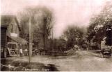
10
The Queensway, Keswick.1900
The Queensway, Keswick, Ontario, Canada
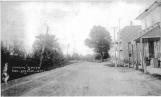
11
Looking south through Belhaven.1900
Belhaven, Ontario, Canada
12
Early in his tenure as Lt. Gov. of Upper Canada, Sir Peregrine Maitland had plans to move the Capital. During the War of 1812 Americans had burned the Parliament buildings at York, and most of the public records. Maitland, with his impressive land-based military career, did not consider that a heavy naval presence on Lake Ontario would secure the safety of York. So he and other Crown officers set about finding a capital for Upper Canada that would be safe from invading Americans. Sir Peregrine believed a waterway could be built from Lake Simcoe to the Ottawa River. Lake Simcoe was already part of the main trade route from Lake Ontario to the Northern Lakes, and then onto the West. Any freight travelling north or south would be confined to well within Canada and no American ships lurking near the border would have opportunity to pillage.13
In 1822 Maitland purchased 200 acres at Roche's Point in North Gwillimbury. Unfortunately for Maitland (and North Gwillimbury), the expense was enormous and no one wished to relocate from Muddy York to yet another swampy wilderness. Maitland was recalled to England and the whole matter was dropped. Over 100 years later the settlement at Roche's Point is still laid out as "Government Reserve," and today Maitland's road names remain unchanged.14
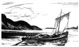
Durham Boat sketch.1800