14
Peace River Crossing.20 August 1912
Peace River Crossing, Alberta
 Credits:
PRMA/MC 82.1271.2
15
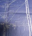
This is a vision of the future development of Peace River Crossing as seen in advertisement for the Smith Bros. Ltd., Land Company (found in Mundy's Pocket Guide to the Peace River Country, 1913). It advocates a railroad bridge crossing the Peace River from a position south of the Heart River and meeting a large subdivision on the other side of the river. The railway bridge which was completed in 1919 crossed the river futher north than shown here. The subdivision illustrated here would have been virtually up the side of a large hill. Such impractical subdivisions were common in the ads and literature of land development companies and would be land owners often found that reality had little in common with the vision they had been presented with.16
A future vision for the development of Peace River Crossing.1913
Peace River Crossing, Alberta
 Credits:
PRMA/MC 78.919a
17
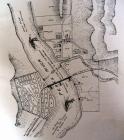
This 1916 fire insurance map shows the main areas of Peace River Crossing that exisited on the east side of the Peace River. The area noted as "1" is the commerical and residential area to the south of the Heart River. The area noted as "2" is the north end of the Main Street. The area south of this (marked in blue and noted as "3") is the commercial area on the south end of Main Street.18
The "layout" of Peace River Crossing.1916
Peace River Crossing, Alberta
 Credits:
PRMA/MC 77.833.79
19
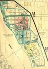
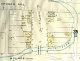
This 1916 fire insurance map of Peace River Crossing shows the layout of streets to be found north of the Heart River. The colored areas marked "2" and "3" are the main commercial areas.20
The layout of Peace River Crossing to the north of the Heart River.1916
Peace River Crossing, Alberta
 Credits:
PRMA/MC 77.833.79
21
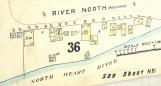
This portion of a 1916 fire insurance map of Peace River Crossing gives a very detailed view of the buildings to be found along the north shore of the Heart River. The area shown has the following boundaries:*to the left (west): Main Street;
*to the right (east): Broadway;
*to the top (north): River North;
*to the bottom (south): the Heart River
In earlier maps of Peace River Crossing few buildings are shown for this area. By 1914 it was home to a line of canvas tents which served as homes and businesses. The area acquired the nickname of "Rotten Row". In 1914 the area was completely washed away in a flood of the Heart River. By the time of the insurance survey shown here (1916) there are 18 buildings illustrated, only one of which is described as a tent. Overall, the buildings show a mixture of homes (marked as "D" for dwelling) and businesses--urban planning and zoning did not exist yet. In addition to the homes and storage buildings there were four shops: a confectionary shop; a barber shop; a second hand store; and a tailor shop.
22
Buildings along the Heart River (north shore).circa 1916
Peace River Crossing, Alberta
 Credits:
PRMA/MC 77.833.79
23
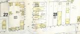
In 1916 the portion of Main Street north of Pat's Creek shown here has a number of dwellings and vacant lots. There are fewer commercial buildings than on the section of the Main Street to the south of Pat's Creek.24
Main Street in Peace River Crossing (north of Pat's Creek).1916
Peace River Crossing, Alberta
 Credits:
PRMA/MC 77.833.79
25
This is a portion of a very detailed 1916 fire insurance map for Peace River Crossing. In this case it shows the buildings (marked in yellow) to be found along Main Street. Unlike other parts of Peace River Crossing Main Street was completely commercial in nature by 1916. This part of Peace River Crossing has a number of stores and offices and includes such things as: the Royal Bank; restaurants; livery stables; the Peace River Hotel; a cold storage area; and a Chinese laundry.26
A section of Main Street.1916
Peace River Crossing, Alberta
 Credits:
PRMA/MC 77.833.79