1
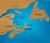
View of Strait of Canso in relation to Atlantic Canada showing its close proximity to Sable Island.22 August 2004
Atlantic Provinces and the Strait of Canso
2
"We were an Island, that rock in the sea" not connected to mainland Nova Scotia or even Canada until the Canso Causeway linked the little rock, Cape Breton, to the rest of North America in 1955.Cape Breton was a separate colony from mainland Nova Scotia from 1784 till 1820 but was a part of it when in 1867, Nova Scotia, New Brunswick, Ontario and Quebec joined to form the new country called Canada.
3
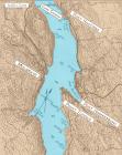
Strait of Canso showing the communities22 August 2004
Strait of Canso, Nova Scotia, Canada
4
The Strait of Canso, then known as the Gut of Canso, was 20 km. (12 miles) in length and up to 1.5 km. (1 mile) and less in some places wide. The communities of East Havre Boucher, Auld's Cove, Mulgrave, Pirate Harbour, Steep Creek, Melford and Sand Point were located on the western shoreline of the Strait of Canso referred to as mainland Nova Scotia. Long Point, Craigmore, Creignish, Troy, Port Hastings, Port Hawkesbury,Point Tupper,Port Malcolm and Bear Island were along the Cape Breton Island shoreline.This area didn't begin to be settled to any extent until the 1780's.
5
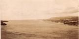
Strait of Canso looking north east1910
Strait of Canso, Nova Scotia, Canada
6
The original inhabitants of this part of the province were the Mi'kmaq. Fishermen were probably the first Europeans to visit our shores on both sides of the Strait, drying their catches of fish before returning home.There are also many local stories about buried treasure being left by visiting pirates - one we know of at Long Pond or Ghost Beach just north of the present day Canso Canal on Cape Breton Island and another below Mulgrave at Pirate Harbour, Guysborough County.
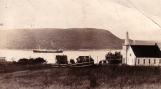
7
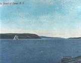
A ship on the Strait of Canso1900
Strait of Canso, Nova Scotia, Canada
8
The deep waters of the Gut of Canso, now referred to as the Strait of Canso, have played a defining role in the lives of the residents of this part of Cape Breton Island and mainland Nova Scotia since the beginning of permanent settlement in the 1780's.9
Douce Elizabeth Balhache's headstone alongside the Canso Canal.2004
Balhache Point, Port Hastings, Cape Breton Island
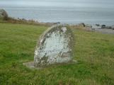
10
Port Hastings located at the entrance of Cape Breton Island was originally called Plaister Cove. Captain Phillip and Douce Balhache who were from the Channel Island of Jersey were granted 200 acres of land back from the shoreline at Port Hastings in the area of the present day Canso Canal in 1788. Their only child's headstone dated 1796 is beside the replica lighthouse on the north side of the bridge crossing the Canso Canal today.As an educated woman, Douce Balhache who became a widow in 1801, played a significant role in community and business affairs in the small village of Plaister Cove until her death in 1834.
11
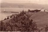
Hugh MacMillan's house overlooking the area where the Canso Canal would be constructed.1920
Port Hastings, Inverness County, Nova Scotia, Canada
12
The largest number of settlers came directly from Scotland especially after 1802. These families settled throughout the area on both sides of the Strait. Hugh MacMillan was one of the leading pioneers who immigrated from Invernesshire, Scotland. He bought a piece of land from widow Douce Balhache in the area of the present day Canso Canal (Cape Breton Island side of the Strait). Hugh carried on a ferry boat service between Auld's Cove and Plaister Cove (Port Hastings) as early as 1819. His family continued this service in the Strait of Canso for the next eighty years. He did some shipbuilding and had the mail contract .The telegraph cable which came across to Cape Breton initially from the top of Cape Porcupine came into his home up on the hill above the present day Canal. That wasn't effective so the cable soon came across under the water.13
St. David's Presbyterian Church (United Church of Canada 1925)1900
Port Hastings, Inverness County, Nova Scotia, Canada
14
St. David's Church was built in 1885, the fourth church built in the community by the Presbyterian families of the Strait of Canso on Cape Breton Island. In 1925, it joined with other Presbyterian, Methodist and Congregationalist congregations to become the United Church of Canada.A ship is seen passing Cape Porcupine on the opposite shore. It was written that a minister once in a prayer said,".... and we thank thee, Lord for the Gut of Canso that separates us from the evil on the other side".