1
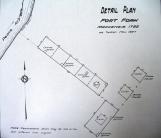
In 1792 Alexander Mackenzie, employed by the North West Company, undertook a huge project--trying to find a practical route to cross North America. The start of his explorations which involved crossing the Rocky Mountains to the Pacific Ocean was his wintering post at Fort Fork on the Peace River. In the fall of 1792 he sent men ahead of him to build the post. It consisted of a series of buildings. When the site was surveyed in 1927 by the Dominion Land Survey there were four buildings found: two store houses for food and trade goods; a building that served as Mackenzie's own private living quarters and a longer building to house everyone else.Fort Fork was used by the North West Company as their major post on the central region of the Peace River until 1805. It was important as a trading centre and also as a provisioning post where the local First Nations would trade meat for goods. Another important aspect of the post was its gardens which produced potatoes and turnips.
2
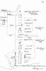
A line drawing of Fort Fork.November 1927
Fort Fork, Peace River, Alberta
 Credits:
PRMA/MC 75.543.207
3
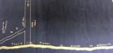
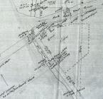
This portion of a Dominion Land Survey map of Peace River Crossing shows the buildings standing near where the original Main Street meets the banks of the Peace River. On either side of the street are the buildings of the Hudson's Bay Company. On the north side of the street (left) one can see the Anglican Church, described as the "English Church" on the map.4
The west end of Main Street in Peace River Crossing.20 August 1912
Peace River Crossing, Alberta
 Credits:
PRMA/MC 82.1271.2
5
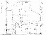
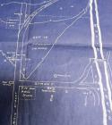
The map shown here is a Dominion Land Survey drawing of the St. Augustine Mission as found in 1908. The right hand side of the map faces east and the Peace River. It reveals all of the major buildings erected by the Oblates on Lot 23 on the Shaftesbury Trail.The Oblates put a major emphasis on being self-sufficient and one often finds livestock and farm land associated with them. The St. Augustine Mission was an example of this. In 1911 a visiting Edmonton Bulletin reporter described what he found at the Mission in terms of agriculture:
"there is about 100 acres of crop all ripe, ready for harvest. On August 22nd, a large field of potatoes was untouched by frost and is expected to yield about 15 bus [bushels]... . Wheat has frequently yielded 40 bushels to the acre. The mission has a herd of about 35 shorthorn cattle and a bunch of horses. Only the cows and the calves and the workhorses are stabled, the rest run free on the prairie and stubble and rustle their winter feed around the straw stack or in the bush. About 30 pigs are raised each year and fattened on vegetables and grain. The grain is hauled down the slope and stacked near the stationary thresher [which] is operated by two horses. ... The threshing is usually done after the fall plowing is finished." (as cited in David Leonard. The Last Great West., p. 360).
6
St. Augustine Mission.27 June 1908
St. Augustine Mission, Shaftesbury Trail
 Credits:
Provincial Archvies of Alberta, 83.376 3011
7
When settlement began in the Peace River area most of it was concentrated along the west bank of the Peace River. This narrow strip stretched south from what was to become Peace River Crossing and when surveyed was divided into river lots that each had river frontage. The settlement was to include farms, a Roman Catholic mission, an Anglican mission and parts of the Duncan's Band Indian Reserve.In the 1911 census there were 60 residents recorded living in the settlement.
8
Shaftesbury Settlement.Early 20th century
Shaftesbury Trail
 Credits:
Provincial Archives of Alberta 83.376, 3011
9
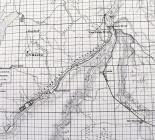
This map, produced by the Dominion Land Survey, shows the route of what was to become the original Main Street in Peace River Crossing. On the bottom of the map Pat's Creek flows into the Peace River. At the top the road to the left of the letter 'E' is the beginning of the Grouard Trail which climbs the eastern wall of the Peace River valley.In 1907 there were few buildings standing on what was the main road through the community. On the north (left) side one finds the Revillon Freres warehouse and a house owned by the Hudson's Bay company. On the other side one finds a house and stable owned by Johnny Gaudet and the buildings of the Hudson's Bay Company (store and two warehouses).
10
Peace River Crossing.1907
Peace River Crossing, Alberta
 Credits:
Provincial Archives of Alberta, 83.376.3011
11
At the time (1909) of this survey map there was very little immediately south of the Heart River in terms of buildings. Most of the area shown here was the property of Felix "Akenum" Shaw, a well known local employee of the Hudson's Bay Company. It is likely that all of the buildings as well as the fenced area shown here belonged to him.Also of interest is a grave yard at the mouth of the Heart River (south side). This grave yard was likely a native burial grounds which first appeared in the late 19th century. It was often referred to as "Akenum's burial grounds" but Felix Shaw was not buried there as is often thought.
The grave yard is currently on the grounds of the Peace River Museum & Archives/Mackenzie Centre.
12
Peace River Crossing south of the Heart River.1909
Peace River Crossing, Alberta
 Credits:
Provincial Archives of Alberta, 83.376.3011
13
This portion of a map drawn up by the Dominion Land Survey in 1912 shows the central area of Peace River Crossing. There are only two major streets: Main Street, running from east to west (top to bottom on this map); and a second unnamed street, running from north to south (left to right on this map). At the time of the survey there were only 75-100 people residing in the community.The buildings described on the map are:
1) On Main Street (starting from the top of the map): a bakery; proposed school site; Revillon Freres store and warehouse; government telegraph building; the new Peace Hotel (under construction); the Hudson's Bay Company.
2) On the unnamed street (starting from the left): the proposed site of the new Hudson's Bay Company stores; the Peace Hotel; the original Revillon Freres buildings. The latter were built by Bredin & Cornwall and taken over by Revillon Freres by 1906.
One can see on the far right of the map the bridge crossing the Heart River.
The sparsity of buildings and population is in stark contrast to later maps and photographs from just a few years later.
14
Peace River Crossing.20 August 1912
Peace River Crossing, Alberta
 Credits:
PRMA/MC 82.1271.2